10 September, 2010

The Architect and the Artist

I've been giving a lot of thought lately to parametric design: that oh-so-fashionable method of design which turns architects into code-writers and computers into designers. I don’t mean to bear down on this method too much, because I do see many purposes for its implementation as a design tool. I can see how parametric design can numerically arrive at what could potentially be the most efficient layout of a space, or best use of a material, or efficient structure. I also see how parametric design can take raw data about wind velocity and temperature, humidity, orientation to the sun, average rainfall, etc, and optimize the layout of a structure such that it provides the maximum benefit of its environment with minimal impact. The utilitarian use of parametric design fascinates me.


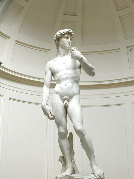
What worries me more is using parametrics as a design driver. Putting my finger on just what makes me worry about it has been more difficult, but I think I’m on the right track: With parametric design an architect can, with a bit of computational magic, create a set of mathematics which results in a perfect sculpture. (Note: the use of “perfect” here does not necessarily signify any aesthetic or cultural exactitude, but instead a faithful application of some theoretical input) But while parametric designer applies mathematics to create sculpture, an artist will create sculpture that inherently uses mathematics. This inverse relationship is not equal. What gets lost in translation is not the ability to create a perfect sculpture – A computer can scan, digitize, and recreate Michelangelo’s “David” down to the slightest knick in the Carrara marble. What the computer cannot recreate is an ephemeral “warmth” or soul to the piece which can only be wrought with the hands of an artist.

[via ArchDaily]

In a similar way I’ve always preferred the drawn line to the plotted line. Something in the inconsistency, the variability, the flow and the changing pressure of graphite on vellum, always seemed to being more life to a drawing than the cold, unwavering plot line.

10 March, 2010

Parking V. Vaughn


Everyone likes movies and television. Everyone likes meeting celebrities. But having film or television shot on your block tends to taint the excitement. In urban neighborhoods parking is already a rarity (as it should be), so when a TV pilot is being shot in the neighborhood and film crews absorb half the streets' parking, it makes for a hectic time...

01 March, 2010

Take from the streets, for they cannot vote.

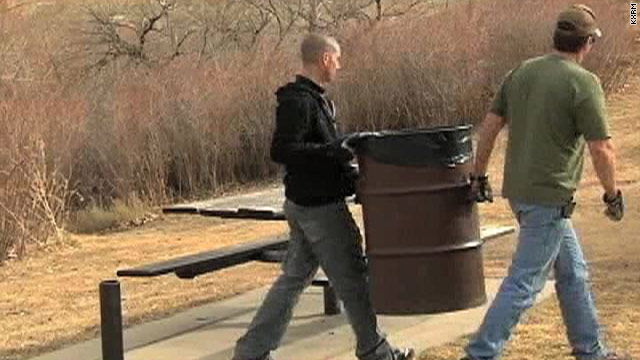
I was saddened to wake up to the news yesterday that in Colorado Springs, the city is removing trash cans and streetlights in the most ill-advised move I can imagine.


The rationale behind such a move is to save the city money. To be fair, CS laws require that all tax increases must be taken to the polls, and the townsfolk chose not to raise their own taxes. But given the many programs that could be reduced or eliminated, these are perhaps two of the worst. 
James Q. Wilson's book Thinking About Crime proved a correlation between the amount of litter in an area and an increase in its crime rate. His theory was that broken windows, litter and graffiti sent a message of instability in the neighborhood that only led to increased levels of broken windows, litter and graffiti. Couple this with the limited reach of street lighting, and you've got a perfect storm for even more vandalism, perhaps even violence. The only thing they could have done worse would be to cut down the trees.

As bad as that may seem, the problem will only compound when the values of the homes on these dark, dirty, littered, unsafe streets begin to plummet, taking their tax revenue with them. 

Soon the streets that used to be so clean and bright and wonderful to walk down in the evening may be so dangerous that increased police presence (and all associated costs) will be needed just to maintain civility. Even if you claim reductio ad absurdum on my last point, the littered streets will require additional manpower to keep them clean. And absent any good-willed denizens, that job falls to the government. 

Colorado Springs is an area with lower rates of crime, and I suppose there's a chance they may be spared the same fate as the cars used in John Q. Wilson's experiments. But by dismantling two of the three *virtually free* pillars of a safe community in order to save the city money in the short run makes the city still looks penny-wise and pound-foolish.

19 February, 2010

Planes, Trains, and Automobiles

 
[via wikipedia]

"Can you wait three minutes?"

This question was posed to me while ordering my dinner from a restaurant in Arlington, Virginia. It was near closing time, and the cooks had begun cleaning up, so my order of fries was going to take a few minutes before they would be ready. The restaurant was surprisingly busy for this late on a Monday night, but I reasoned that the massive accumulation of snow outside had not just canceled my train home, it had also shut down streets, grocery stores, and restaurants across the entire region.

I had prepared myself for a quick, three-day trip to Washington, DC to interview with a few firms. When one interviewer asked me if I would be able to meet with another person on Monday (the person I would be working more directly with) I reluctantly agreed. This was Super Bowl Weekend, and I was planning on hosting a party on Sunday night. But if the extra time would help me land the job, I was willing to stay. The Super Bowl was not my only reason for wanting to leave on time - the snow was just beginning to fall, and many business had already closed in anticipation of the snow. My lack of understanding just what was about to take place was underscored by the comment I made to the interviewer:

"You know what we call this in Chicago?"
"What's that?"
"June"

The snows began on Saturday. On Sunday the skies parted and cabin-fevered Washingtonians began to take to the street. The street scene was one I truly enjoyed seeing; the streets were hardly plowed, to say nothing of the sidewalks, and there were few vehicles out. In their stead, throngs of people could be seen walking up and down the newly pedestrianized streets amidst the winter wonderland. The collective need surpassed our selfishness, and people could be seen digging out sidewalks, removing snow from a neighbors' roof, or pushing a car out of a snow-fortified parking space. It was a stunning moment of humanity in which I saw the possibilities of a pedestrianized world and the potential of all the networks and relationships that could be forged when we no longer passed by each other at 40 miles an hour, but had time to wave, say "hi", and ask how a strangers' day has been going. I wish I would have had my camera.

After I found out I was going to be staying until Monday, I traded my Saturday train ticket for one on Tuesday morning. This was a simple process, and I applaud Amtrak for its ease. But neither train was to leave; both were canceled, logically, due to the heavy amounts of snow accumulation strung between DC and Chicago. If the trip is normally 17 hours, imagine that same trip plowing through 26 inches of snow. I rescheduled again, this time for Wednesday. It was also at this time that I booked a cheap flight out of Dulles. While I was glad to be arriving in Chicago 36 hours earlier than I would have on Amtrak, I was slightly disappointed that I couldn't complete my round-trip journey by train alone. 

Tuesday's blizzard only compounded the problems. In addition to the trains not running, the airports had closed indefinitely, and me without a car, was stuck there to wait it out. I knew beforehand that America had a love affair with cars, but I've always been biased toward mass transit, and so I could overlook its deficiencies. But stranded in DC with no way of leaving, no way to get around, I was given no choice but to come to grips with the fact that America NEEDS cars. Yes, we can build a national high-speed rail network, and it will increase usage over today's ridership, but America came into its own during the automobile revolution, and as a result we have larger, more spread out cities in varied locations with little option to connect it all with any type of mass transit. Short of dynamiting each American city and starting from scratch, America will require a lot of cars.

And the cars we need do not need to look like the cars we have. Smaller, more efficient cars, cars that stack or compact, cars made for one or two people, cars that include towing or carrying capacity. Wind-, Solar-, and Geothermal-generated Hydrogen or electric cars can replace the internal combustion engine. Carpooling, rideshare, rentals, all are potential avenues for the new automobile. As my 4 canceled trains and 3 flights indicate, cars will be necessary.

And like most Earth-saving technologies, the market, policies, financing, technologies, or innovations are preventing them from hitting the streets today. So we should work toward many solutions, generating them in myriad ways, the same way one of my myriad schemes to get home finally panned out. Because some technologies will sputter out and some will be canceled, but given enough time one will carry us home.

So can I wait 3 minutes? You bet.

02 February, 2010

High-Speed Rail in America

This week I will be taking a 17 hour journey by train from Chicago to our nations' capital. I'm quite excited, as this will be my very first cross-country trip via Amtrak. Moreover, I am very pleased that I will be able to go from my house to Union Station to Washington DC, to Silver Spring, MD, to Bethesda, MD, back to DC, then to Chicago, and back to my front door, all without setting foot in a single car. The trip will span 5 states, involve 3 mass transit systems, and will include an estimated 40 hours on one for of train or another. Needless to say, I'm taking a few books.

What I find amazing about all of this is that someone like myself - a confessed TrainGeek and mobility infrastructure wonk - has yet in my life embarked on such a journey. I've taken similar routes in Europe, where I traveled from the small village of Didcot in England, to within 200' of my apartment in Paris. Of course that trip utilised Europes' high-speed rail connections, and which saw me across four train systems and two countries, all in about 6 hours. But this trip on Amtrak is quite different. Amtrak is a notoriously slow and unreliable service. In its entire history it has failed to turn a single year of profit, and thus relies heavily on government subsidies. I nearly opted against this excursion on Amtrak, as the total travel time will nearly double, and the cost is slightly higher than would be the cost of gas for the trip. The only reason I'm willing to make these concessions is that I don't like driving, and I do like the free time granted by rail travel. Indeed if I weren't such a geek about trains, there is little chance I would not have driven my car all that way. Unfortunately for Amtrak, there are few people like myself that are willing to make such concessions.

And thus the great American High-Speed Rail Gamble: Obama is putting a great deal of money on the line that if given the choice between driving or flying, or having the option to travel on relatively inexpensive, reliable, safe, and convenient high-speed rail, that Americans will choose the latter. Even with my obvious biases toward rail (I would love to visit any medium-sized metropolitan city without setting foot in a car), I do feel that this is a realistic and as-of-yet unresolved issue. To provide high-speed rail in the quantity and quality required to turn a profit, costs may end up being prohibitive to flying. If you seek to provide cheap, reliable service you will end up sacrificing quality.
And so on.

Therefore I hold the belief that if you are to provide the type of service, quality, etc, required to convince people that rail is a viable option, AND you provide it at a cost similar to or less than driving, you must first revolutionize the way we think about "high-speed rail" I do not believe that the European or Asian models will work in America. This is what I think will:

Dedicated, elevated rail: Amtrak faces its sloth and inconsistency on two factors: 1)They share rail lines with freight trains, and often are the second-priority when it comes to sharing a single track. This results in increased stoppage time, and when they can run,  2) track quality, contextual issues, and imposed speed regulations prevent the trains from achieving a speed necessary to provide quick transit. By providing dedicated tracks the trains will be able to travel smoothly and consistently. By elevating the track, the risk of animals or debris on the tracks is reduced and speeds can be increased.

Electrified rail: The second advantage to elevated rail is that the system can be provided ample, secure electricity to power the trains. This can also lead to cleaner transit if the power is generated sustainably.

Solar Power: With over 87 million square feet of potential surface area along the rail between Chicago and DC, there's ample opportunity to install solar panels along many different lengths. The panels would have direct access to sunlight, and would be able to easily power the entire rail system, thus providing clean, cheap energy. There's potential for additional profit if Amtrak sells power back to the grid when not in use.


Computerized trains: Having studied the CTA budget, it's plain to see that the highest cost to any mass transit program is its manpower. While I would certainly never suggest fully automating a 200 MPH train with hundreds of live aboard, there's certainly an ability to automate many functions of rail travel, which reduces costs and reduces the risk of human error. One engineer aboard a bullet train could pilot the vehicle, while the computer monitors the engines, the passenger cars, and the track ahead. Automating certain aspects of the stations would further prohibit human error and improve safety. Maintenance of tracks and vehicles would be much more efficient if the tracks and vehicles were monitoring themselves and pointing mechanics to specific issues, instead of lengthy and costly maintenance overhauls on healthy trains.

Smart Ticketing: The ability exists today to implement a ticketing system that would provide any industry (airlines, hotels, sports venues, etc) with the right balance of occupancy and profit. Creating a program that analyzes trends in hourly, daily, monthly, yearly, and 5-year purchasing, companies could simply input their desired occupancy (75% full, 95% full, etc.) and the program would constantly adjust prices so that the cost rises when demand rises and lowers when demand lowers. As the scheduled departure approaches ticket prices would increase or decrease dramatically in order to fill the requisite seats. This system could be a boon to business class and other last-minute travelers, as they will be able to find inexpensive seats (as opposed to astronomical airline prices) and the train is able to make a bit more money by filling up the last remaining seats.

These are a few. I'm sure I'll add to this list upon my return.

20 January, 2010

The Land of the Rings


Artist Roy Prol take a look at Earth if it had the rings of Saturn.

13 January, 2010

Of Millenia and Mirrors

One simply does not study under the tutelage of one Professor Waldman without an appreciation for mirrors, specifically mirrors which reflect alternate realities, passageways, and other immaterial ephemera. So when Roosevelt University announces plans to construct a new building along South Michigan, I cannot but see the bi-colored and reflective glass as a large mirror, reflecting the city and heavens.

So what is the effect of such reflected glazing (referred to as "mirrors") on the city, and what does it say about the architecture it envelopes? In the mid-century, modernists were using glass in part for the purpose of mirroring the external world. Examples like Lever House and the Hancock Building used glass to immaterialize their buildings - by cladding the structure in mirrors, one could create the effect of transparency, the irony being they were so opaque one could not see 3/8" past the surface.

This implication is perhaps more revelatory than simply playing with reflections. Mirrors used to disguise the true shape of a building, or employed to visually trick the onlooker into believing the building is smaller implies an apologetic demeanor, as if to offer a feeble mea culpa to the surrounding urbanism for such an obviously intrusive and incongruous bit of fabric. If there is any merit to this argument (and a quick look at some of the early mirrored buildings finds a pattern of incongruity with their fabric), then one might argue that buildings (or their architects) are self-aware - and self-conscious. Look at high-rises and skyscrapers built in the last 15 years, and the self-conscious apologetics of mirrored glass disappear. In their wake are buildings that stand tall and proud, determined to make a statement of themselves amongst the milieu of other tall buildings (see aqua tower). However, one key element has changed - the height of the surrounding urbanism. No longer are these tall buildings the pioneers of their locations. Unless a building is going exceedingly tall, there is no longer an incongruity of urbanism, and tall buildings are allowed to flaunt thier style with reckless inhibition. Even amongst the tallest buildings, there are examples of a mixture of attitudes toward environments; Burj Dubai stands alone within its context. It's clad in mirrors yes, but its shape and the curvature of the glass minimizes the effects of mirroring, and the building is allowed to stand alone. Trump Tower in Chicago is a second example. This building (some have speculated its role as a precursor to the burj dubai, given a similar structural language and both designed by Adrian Smith at SOM) begins to mirror its surroundings and the sky, minimizing its impact on the landscape.Although located along the Chicago River just north of the loop, it breaks away from the other tall buildings of the city and stands alone, an effect exaggerated when approaching the city some 10-20 miles out. The Spire offers another example, as does the now-underway Freedom Tower in New York City, which perhaps does the best job of treading a fine line between apologetic mirroring and brazen statement.

No doubt there are other interpretations of mirrors and buildings. I would like to revisit the use of mirrors on many of the structures around Millenium park, from the Pritzker Pavilion to the Bean, to the mirrors found on the wet pavement at Crown Fountain. This picture begins to hint at the phenomenal possibilities of mirrors which provide a glimpse of another world beyond. Such an idea is not to be found in many of the mirrored buildings we see today, that try to hide themselves from view. Instead mirrors to the moon provide visual access to exciting alternatives, which can truly be experienced at eye-level.
[via rjseg1]


05 January, 2010

Good Grief.


Last week I took the El down to Belmont and made the short trip to Intelligentsia Cafe. I enjoy their coffee and an occasional baked good, and as there are always a few open seats I stay a while and read or sketch. I also enjoy the Lakeview neighborhood.

I believe that my mind is naturally tuned to "Good" places. I define "Good" as places that have many of the devices that make places livable, interesting, engaging, and livable. These are the neighborhoods that are always lively and filled with activity, the places one goes if they wish to people-watch, or are just out for the evening without plans to see a movie, play, concert, or other form of entertainment. Good places are entertainment. But they are so much more, and what they are changes from year to year, season to season, even hour to hour. Many people like Good places, and they flock to them for many reasons. I am trying to understand those reasons, and what effect the built environment has on the making of Good places.

I believe that the Lakeview neighborhood, specifically the Broadway-Halsted corridor between Addison and Diversey, is a Good place. Rather, they are made up of several Good places, placed in a line and connected by short lengths of less-good places. As a result much of my thinking on what makes Good places comes from the 5-10 minute walk between the El stop and the Coffee Shop. This is by NO means the best or only Good place in Chicago, but given the frequency of my trips for caffeine, I have certainly developed a bias.

My quest to find Good places has been going on for years, in one way or another. While I was studying in Paris, the purpose of my entire fellowship was to form a pattern-book of sorts, but over the length of my time in Paris, I came to realize that cities as a whole are much more nebulous; that Paris, or Venice, or Las Vegas, or Kandy, Sri Lanka, or New Orleans, or Chicago, do not have a singular language or set of patterns that make them Good. Each of them follows certain a certain dictum of form, space, and hierarchy, but these in and of themselves do not guarantee Good places. The answer is nebulous.

So I offer a change of direction. Instead of Good places, let's look at Good spaces. This is the built environment; the making of space, the articulation of edges, and the ephemeral thickness that exists between them. A scaffolding for Good places.

29 December, 2009

Power Drive


If, like myself and 30% of the rest of America, you found yourself taking to the roads this holiday season, there's good chance you were cruising along some of the 46,876 miles of interstate spread across the country. I found myself taking an afternoon jaunt on I-39 between Chicago and St. Louis, and just as the last daylight was fading, came across the Mendota Hills Wind Farm. At just under 52 MW of total generating power its not the most powerful wind farm, but its proximity to the interstate and the sweeping vistas offered by glacial-flat farmland is enough to satisfy the infrastructure geek in me.


It amazes me that people still oppose these things. Seeing them spread across the fields like quiet sentinels, their power appreciated when comparing their size to the speed of the blades. Considering how little space they take up (compared to, say, solar) they really work well in agricultural settings. I can see how they may be considered an eyesore, but to me they are the true model of progress; free fuel from the earth, with no emissions, no sending our money to other countries... this is national security, plain and simple.

And it was that thought that piqued my interest. Here I was, gliding along a 240-mile stretch of highway that unarguably has had a major impact on the shaping of cities, a nation, and even an economy, and it was all justified as a national security measure. When Eisenhower proposed the Interstate System he billed it as necessary for the country to be able to mobilize the military and evacuate cities, and even for landing aircaft; the network mandates a certain proportion of straight, flat, clear stretches of highway to be used as emergency airstrips.

60 years later we are faced with a similar need for national security, only this time its energy security. President Obama's Stimulus spending provides funds (and not enough, in my opinion) for creating renewable power generation. Given the partisan fight that raged in DC during the creation of the bill, I do not believe that the need for renewable energy was framed enough as a national security measure; instead it continued to be framed as a global climate change issue, something that can (unfortunately) be made a political issue. Had the Obama Administration simply come out and say "Global climate change or not, this is good for the energy independence of America", it might have been passed with much broader support. But enough of my soapbox.


 [image: 63 Turbines of the Mendota Hills Wind Farm]

I'm more interested in the application. I've always been intrigued by the highway median: the long, narrow strip of no-mans land which finds its way from major city to major city, a permanent easement whose use would hinder no privately held land. I'd like to put a high-speed rail there. Or local trains. I'd like to cover it with solar panels or line it with fiber-optics, or even fill it with our trash, at once creating a natural barrier between oncoming traffic and taking us to task for our wasteful habits. Now add one more ingredient to my median-infrastructure soup: Wind Power.


Not only an amusing way to combat Highway Hypnosis (watching turbines rotate is much like watching a campfire, or ocean waves, its quite mesmerizing), the turbines would also provide critical locally-generated power where it is needed most. Even placing turbines only at overpasses would minimize power generation, as one can assume whenever overpasses are near, homes and towns cannot be too far beyond. And locally-produced power would more than make up the deficit caused by line loss when transmitting to the few and far-between agricultural consumers. Placing only at overpasses would also keep intact the lengths of highway/airstrip that helped generate support of the initial projects.

The only thing that could make it better is if enough turbines could be placed to power a high-speed mag-lev train in the median, and thus scratching one thing off my infrastructural Christmas list.

22 December, 2009

Immaterial Spaces


I came across an interesting experiment by Timo Arnall and Einar Sneve Martinussen from AHO and Jack Schulze from BERG, in which they mapped the space created by waves emitted from RFID chips. By creating a rig that would trigger an LED each time it entered the RFID field, and capturing these moments on time-lapse photographs, the team was able to create 2-D images of the field. Then, by sequencing the 2-D images in a series of slice, created a 3-dimensional representation of the field. Video here.

 The fields being given off by many different technologies, from microwave ovens to CTA cards, to Wi-Fi hubs and radio stations, can each be spatially mapped to understand their limitations. Mapping an "immaterial space" can have enormous potential for all types of industries. Radio and telecom industries could have accurate maps displaying service areas and signal strength. Verizon could finally get rid of their one-man signal verifier in favor of a legion of receptors atop their vehicles.

Perhaps more intriguing is its application to the built environment. Libraries, cafes, and homes are formed to the boundaries of a Wi-Fi hub. Walls are built to move in sync with signal fluctuations. Groundbreaking ceremonies now include the first powering-on of the hubs. Technology has officially replaced masonry as the new cornerstones of our buildings, its signal our scaffolding. Transcribe the technology to map audible environments and you can determine the volume of space in which the sustained decibel level is above 65. This would be of great interest to residential developers, hospitals and schools, or anyone else that doesn't want to live behind a concrete barrier near a highway or airport.

The technology will have officially permeated our market when it becomes an iPhone app. People hold out their phones like divining rods in search of strong signals. Hi-tech games of hide-and-go-seek with your friends running about the city. A second wave of geocachers search for small beacons hidden in mundane locations. Indeed these experiments have opened up more possibilities than just a graphic for the technology.


What if the technology is attached to brain wave sensors, sold in handy packages over the counter. Instantly your emotions are given a definition and a space; people can measure how sad you are in cubic feet, or literally step inside your "happy place", or know just how far away to stand when you're angry. If an architecture can be made to respond to these readings (possibly with inflatable materials), we could create rooms that are always just the right size-always intimate without being confining. Or in prisons, where the devices are programmed inversely, so the angrier and more dangerous you are, the smaller your cell.

15 December, 2009

Guadalajara Post-Mordem.

Across a litany of issues that I have recorded as being my personal criticisms of the Guadalajara project, including many issues that I wish to research deeper, there was one that sort of stuck out most. During the design phase of the competition I was well aware that my project was more "real" than what the competition was looking for. More specifically, they were looking for ideas on what a city in this location could be whereas I was really setting out a new system for ordering urban conditions - many of the ideas I had been developing for several years, and here was a chance to apply them all in a real-world location, with a geography I could actually use to form these lucid ideas.


So when the winning entry is announced, I notice two things about it: a) it is similar to mine, but taken further, and b) I need to take my projects further.

Again, I'm trapped in this cycle of thinking that my project was too "real" and didn't push the boundaries enough, then reminding myself that these were ideas I wanted to explore. Perhaps now that I've put them down on paper I can begin to explore them further. So here's an abbreviated analysis of the two projects.

Both projects are exploring a linear mobility structure, accentuated with openings and enlargements at key intervals. Whereas my project explored this idea in plan and ultimately placed these linear routes onto the landscape, the winning design explores the idea sectionally and subtractively by carving them from stone. I've always felt that these are two of the weaker points of studying at UWM, that I have been trained to well in designing in plan and not well enough designing subtractively. Perhaps this is one of the lessons I will take away from this project. The two schemes are designed at completely different densities and populations, and having my target population in mind would muddy the other concept.


What gives me hope is that I am on the correct path; that this idea of a linear system punctuated by public space is a valid strategy. I think that burying it in the face of the mountain is a beautiful move, and its excitement, if not feasible or practical, is stunning (but there's those words again!). I'd like to say that had I not been transcribing previous ideas I would have had a similar response but I don't think I would have. A catalogue of my work shows a consistent failure to push design far enough to leave the realm of pragmatism and enter pure architectural speculation.

My final project at UVA was a similar venture, laden with good intentions but stifled by pragmatism. During my final review I was told that my project would be really great if I had had another 2 weeks to work on it but I've never been sure about that. Once I gave that same criticism to a student a few weeks ago and I realized what it meant: it's not that the project wasn't refined, it's that it was too refined. Boxed in by my own perception of what a final product should be, I resort to details when I have yet to capture the potential spirit of the concept. I can only hope that I will be able to take that away from this competition; that I should continue to explore and model, think in all planes before committing. Yes I had only a week. Yes I was recording my ideas into one project. But that should not keep me from taking it further.

01 December, 2009

Theory and Practice: Guadalajara - Part II

Many of the ideas for the ArpaFIL competition are several years old. If I were to explain their origins as a narrative, I would probably tell a story about how I was driving through West Virginia on a trip home to Chicago. West Virginia is one of the best drives I've taken; the constant undulations of the road along the X, Y, and Z axes makes for an engaging trip, all the while a panoramic of tree-covered mountains inhabits the background. During a particularly long ascent I began to think about how I was in hour 2 of a 14 hour drive, and that I would much prefer taking a train (as origin stories go, this one goes even further back, to a midnight train ride through the Swiss Alps which I found particularly fascinating). I began designing in my mind a method of creating a high-speed rail line that would occupy the grassy median of the highway. Of course it would have to be elevated, so a sleepy driver would not plow his car or truck into an oncoming train. And the space below could be used to carry cable, fiber optics, power, etc. If given a bit more room, this space could carry slower-moving freight trains. Or regional trains. It was the genesis of the circulation spine.


The spine itself was one concept. It provided a solution to the issue of mobility infrastructure that could be applied to other ideas about land usage which I had studied in Christopher Alexander's A Pattern Language. 
A Pattern addressing towns (#3, City Country Fingers) allows for a region of high density to be placed in close proximity to natural and agricultural, zero-density regions. Flying in the face of modern American suburbanization, this system creates a greater area of intact ecology and exposes the greatest number of citizens to its benefits, without putting either ecology at risk. Alexander's book has had a greater effect on my thinking than I realized; While pattern 3 was my primary tool for organizing large tracts of land in the New Guadalajara, I had inadvertently also applied #2 (The Distribution of towns) to my mobility infrastructure network, and #'s 4 and 6 to the lower-density regions. Going back through A Pattern Language, I see that still many more patterns exist in part or in whole, throughout my design.

What has driven the circulation spine as an organizing element has been a desire to reduce the dependency on motorized traffic. Having lived in towns from 30,000 to 3,000,000, I have really always been able to minimize the amount of driving that was necessary. While I have driven a car since I was 16, in High School I was able to ride my bike to school. In Milwaukee and Charlottesville I could easily walk to classes. In Milwaukee and Chicago I have been able to take public transportation to most of my destinations. In fact, many of the businesses I choose to frequent are chosen in no small part because of their proximity to an El stop or a bus. This is crucial in my observations of the urban landscape; Having fewer cars on the roads means less parking, which means more pedestrians, which means more intimate shops with windows, which makes the streets safer, which means more pedestrians, which brings in more business, which makes the neighborhood thrive, which reduces crime, which brings more pedestrians and more income, which improves the quality of life and air and sound and all the things that make cities wonderful. On the other hand, more cars means more parking, means greater distances between stores, means inward-focused stores, means fewer eyes on the street, means greater crime, means fewer pedestrians, means more cars. Both are self-fulfilling prophecies. America is currently caught in a downward vehicular spiral. My interest is in seeing what it would be to have an upward, pedestrian cycle.
By combining a pedestrian-focused urban landscape with an organizational circulation spine, the city begins to take shape. Pedestrian streets run perpendicular to local rail stops at 400 foot intervals, equivalent to half of every El stop. Pedestrian streets run about 1500 feet at their longest, which allows even the farthest buildings to be walkable to a train. By staying within this 3000-foot corridor, there is not a single inhabitant of the city that cannot reach a train with a 10 minutes' walk.
Corresponding to this layout, a pattern of density emerges which is highest at a point where pedestrian routes meet the circulation spine. Akin to a major intersection in a city, these points receive high traffic counts in relation to the far ends of a street. The natural response to to place a greater number of people and businesses near these intersections. Fully 50% of the citizens of the New Guadalajara will live or work within 500 feet of a train station.

The shape of the city has changed. From the centralized shape of a traditional Roman town or Medieval castle town, or the center-less sprawl of an American frontier town, the city has taken on a linear shape, with bulges occurring at cities along the serpentine spine. The shape is without precedent, but the precedents required for city-building have changed. Cities no longer require an elevated position for defensive purposes. Access to a river is no longer needed for water, which is pumped from aquifers; or shipping, as shipments are now made by rail, truck, or plane. The only regulating factor in developing the New Guadalajara was the preservation of natural features. The spine runs along the bases of mountains. Agricultural land is pushed out of the way of forests and riparian corridors. Even the city yields to the right-of-way of streams and natural foothills. The city is subservient to nature, and will adjust itself to suit the landscape. A very un-American concept.

From the omnipresent regulation of the circulation spine comes a new interpretation of wayfinding hierarchy. Whereas the modern highway system organizes itself as a datum, off of which one can find rest stops, towns, or other concrete ribbons, the circulation spine of the New Guadalajara is imagined as an enfilade of public spaces, set in an hierarchical organization. Arriving to the region from a distant location (to Guadalajara from, say, Los Angeles) one would have to transfer from this fastest mode of transportation to a regional train to the city of your destination. From that regional train another transfer to a local train, which makes stops at each perpendicular pedestrian street along the way. Each of these transfer points becomes a hub of public activity, and varies in its size and density from top to bottom.
Even on the street, one must pass through an enfilade of plazas, starting with a central plaza (the largest would be below the regional rail hub) and moving outward, getting progressively smaller, until the outermost plaza may be a small, intimate garden. Moving from one to another  acts as a wayfinding device, while also bringing life and activity to the surrounding buildings.
Once at your destination building, one must again traverse the enfilade of public spaces embedded within the building. Somewhat akin to a sky lobby, this may be a small outdoor garden, it may be an enclosed foyer, or it may be a large plaza set within the building. A traveler will make their way up to the appropriate lobby, and will then move on a set of local stairs or elevator to to appropriate floor. The sky gardens provide a sense of community and security in a building of enormous scale and density.

A few simple concepts combine to create a complex urban landscape of density and hierarchy. The concepts themselves allow for a large city which reduces vehicular traffic and pollution, provides renewable energy to its citizens, allows for a quality of life and community rarely seen today, and can even be self-sustaining, given the amount of quality agricultural land available to feed its citizenry. The New Guadalajara has been a significant exercise in creating a city of considerable size and density while maintaining an environmental and social quality of life.


My greatest criticism of my own project may be its lack of understanding of Guadalajaran culture, or Mexico's urban process. Many of the elements and proposals I utilize stem from a criticism of American urbanism and some problems may be confined to America. On the surface I understand that this project may not reflect the social, cultural, and urban needs of Guadalajara, but at the same time I never expected them to be. This project always was supposed to be a vehicle for the ideas and concepts I had already created but never applied in any disciplined manner. Even if the project was not meant to tackle Mexican urabnism, I would have appreciated a greater understanding and application. That may be my main criticism, and I'll spend more time on that criticism next time. This competition was a first step of many in understanding a relationship that could exist between architecture and urbanism. It deserves my honest assessments.
18 November, 2009

Built in a Week: Guadalajara - Part I

After realizing the competition entry date was earlier than expected, compounded with the knowledge that the 4' long board has to be completed, printed, and in Guadalajara in 10 days, I've been a little busy cranking on images. So I'll post some here, with an update to follow once all is sent out.


13 November, 2009

Invisible City


What happens when a city returns to nature? Where do the people go? What if the 1.5 million inhabitants of Guadalajara decided today that they wanted to go elsewhere? Maybe they go home, pack up their books, wrap their glassware in newspaper, place everything in boxes and ship it all off to some other place. Then, they begin unscrewing lightbulbs, taking doors off their hinges, removing windows from their sashes. They tear down the brick walls and stack the materials in crates. Then they pull up their driveways, waiting momentarily while a truck rolls  the street up like a giant rug. Someone plucks the streetlights from their bases, and another collects manholes (and not just the covers). Entire buildings are dismantled, parking lots removed, soil replaced, and all signs of civilization are secreted away. Maybe overnight.

And then the sun rises and nature has made her comeback. The grasses spring up for the first time in decades underneath a foundation that no longer exists. Rabbits make homes in abandoned storm sewers. The people, meanwhile, have all gone to holiday in Puerto Vallarta, bringing their lamps and their grocery stores and gas stations with them. They bring the office, because we may be here a while.

Then, while they are gone, what once was Guadalajara begins to be remade. Smaller, fresher, more compact. Instead of sprawling suburbs, mid-rise buildings sprawl to the heavens. Tall towers mark the locations of highly dense neighborhoods and business districts. Everything seems to cling fast to a serpentine pathway- a spline of cars, trains, and pedestrians. The inhabitants of New Puerto Vallarta begin the exodus back to their ancestral homes, only now the scene is much different; the city is very narrow, and everything is walkable from one of these new transit hubs. Buildings are organized much the same way, as elevators and escalators and stairs take people first to sky gardens, then to their destination. Over time the new city of Guadalajara will fill in with all its previous inhabitants, and will add another 300,000 in babies and curious onlookers. But the city they return to now offers stunning views of natural forests and riparian streams infilled with serene agriculture (enough to feed the entire city).

10 November, 2009

Possible Cities


ArpaFIL is hosting a design competition to re-imagine the city in a more harmonius balance with the environment and with its inhabitants. The competition essentially wipes the city of Guadalajara, Mexico off the face of the earth and the challenge is to create a city from scratch given only the natural topography of the land. The competition is quite daunting, if not for its size alone. But it also serves as the perfect venue for exploring many of the concepts and theories about urban development, architecture, infrastructure, and the spaces between that I have been developing for years. The project is becoming a proving ground for a new type of urbanism. I hope that the competition will also serve as the centerpiece of a few blog entries.

In essence, the project can be seen as a study of hierarchy in scale; The project is organized around a central transit spine which includes international high-speed rail, regional rail, and local train service, highways and local lanes, even pedestrian routes. Development forms along the spine, increasing in size and density as transit nodes grow nearer. Layered upon this built form is one controlled by the natural topography: Low/zero density forests and wildlife refuges, interconnected riparian zones along streams and lakes, and low mountains framing and containing the natural limits of the city. In the geographic center of the city, where most cities are at their densest, agrarian farmland and Solar Stirling power generation.

The most unfortunate aspect of the competition is that all information must be submitted on one 30" x 40" presentation board. With a few years of concepts finally being overlayed and analyzed, there's sure to be more information than can be submitted. Rejoice, for that is what will be covered here!

04 November, 2009

The Edifice Complex

Much of my research has focused on the threshold between the individual building and its larger built environment. When I was studying in Paris, I spent a lot of time studying contemporary architecture in a city which gets most of its character from ideas and standards that were implemented 130 years ago. I would study buildings by Christian de Portzamparc, or Massimiliano Fuksas, or Jean Nouvel. My bias in interpreting the works was that everything was in some way responding to its context, either by holding the street edge, or following window lines or cornice heights. Everything was, in my mind, sort of shoe-horned into place in the city. I'm beginning to wonder now if that is necessarily true, or if it was by own desire to see that happening. My senses tell me that some are responding more than others. A fair assessment.

Lucia Phinney told me that what I was really studying in Paris were "screens", these veiled elements that were really about separating disparate conditions, be they public versus private, or deeper; in my assessment of the city itself, there was a dichotomy between the public and more touristy areas which were rather pristine, and working-class neighborhoods in the 9th and 10th arrondissements that epitomized the real Paris: a large city with its problems of homelessness, crime, vandalism, etc. According to Phinney, much of my research was an attempt to identify that threshold. Now that I'm back in the States, back in Chicago, I am again finding myself interested in identifying these screens and thresholds.

When it comes to defining thresholds, I have a better idea of what they are not than what they are. I know that I am not just interested in the facades of buildings. The facade is an important aspect of defining the threshold in that it informs and is informed by its context and regulates the privacy gradient. But I have found that by exploring the alleys one can find a truer assessment of what is happening in a building. It's as if the experiential limits of the building are held tight against the facade of the building, but in an alley the limits are extended, perhaps halfway down the block. When you get tot the scale of the city, tings begin to change. Up close is when you feel the weight of the city bearing down on you. Cognitive maps provide barriers with small openings instead of fluid space. However one can be 20 miles out of town and still feel they are connected- this weekend I was traveling through Indiana and could still see the skyline in the distance.

Thresholds are very nebulous. Depending on the scale of the artifact and the level of engagement it can hold tight against a building or be miles away. A screen can be paper-thin or a thick space of transition, and can change with the changing elements of a building, even changing with the diurnal and seasonal periods. I hope I can continue to explore these phenomena in the streets and neighborhoods of Chicago.

27 October, 2009

The year of the Rat


Reuters posted an article ranking the nation's top cities and their potential for Rodent Infestation. Chicago moves up the list 2 spaces since 2007, taking the #6 spot. The list nominates New York City in the top spot for both 2007 and 2009, although other East Coast cities fared better: Boston dropped below Chicago to #7, and Baltimore and Washington DC are both dropped from the 2009 list, having previously been higher up than Chicago.

The study used "U.S. Census Bureau data in combination with a host of key factors, including city revenue spent on infrastructure maintenance, climatic factors which affect rodent populations along with records of pest control sales." The study also "included new U.S. Bureau of Labor data on municipal rates of unemployment and foreclosure filings to revise their assessment from their 2007 report."


The takeaway message for Chicago is simple, but with complex overtones. While the city cannot control variables like warmer winters or even foreclosure rates, maintaining infrastructure and funding prevention measures can be addressed. And for a city that is already underfunding infrastructure, the cheaper the better.


23 October, 2009

Architecture, Urbanism, and the Design of Dying


As humans we have a strange relationship with death. The only species known to bury their dead, we approach the matter the only way we know how, and that is the same way we approach life. We each mourn our own way, perform the appropriate ceremonies, and then we adorn the newly departed with their own structures and architectures of stone, granite, plaster and metal. We shelter them from the elements by placing them in a tomb, then marking their location and memory with headstones, crypts, monuments or placards. Architecture may be the only thing we can take with us. In Paris, these burial plots combine to form districts of the cemetery, which are divided by boulevards, streets, or pathways. These in turn are given identification, and street signs are erected. At certain intersections, a large obelisk or sepulcher may be placed in the center, declaring itself a landmark from which visitors can get their bearings and migrate in the right direction. By applying theories of architecture and urbanism as understood by the living to places inhabited by the dead, cemeteries become places where two worlds meet and occupy the same space, both in the physical sense and symbolically. Although used for many activities in a densely packed city of bustling vibrancy these cemeteries, with their urban organization and architectural exonerations are still places of memory, of respect and somber reflection on our own mortality.

-Excerpt from Complex Context, my Nix Fellowship thesis work.

21 October, 2009

Aerial Internment


The October issue of Chicago Magazine ran an article about St. Johannes Cemetary, the 5-acre plot of land that has become a spot of contention for the future development plans of O'Hare Airport. Mayor Daley is staking a lot on the modernization of the airport, but descendants of the 160 year-old cemetery's residents are understandably peeved.

While I'm sure there are numerous legal precedents for this type of clash between eternal land rights and the forces of progress, I'm more interested in the architectural and infrastructural ramifications. What if the cemetery stayed? What if the two shared custody of the ground? Could the runway be elevated off the ground? Perhaps in the dead of night 12 CF-47 Chinook helicopters could grab the parcel by the edges and hoist it above the ground. Then fly the whole lot, dirt and all, to plug up a nearby depression in the earth. Maybe place it in an abandoned gravel quarry. Or revive John Ronan's vision for the Old Post Office.

I can only imagine that the final solution should somehow balance the needs of both the cemetery and the airport. Perhaps the permanent levitation of a large swath of land in the airspace above a runway. A literal translation of the metaphorical ascent to heaven, aided not by divine redemption but by aged DeHavilland turboprops.


19 October, 2009

Talking Tall

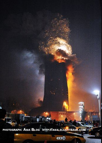
Cityscapes on Friday published an article about the upcoming conference hosted by the Council on Tall Buildings and Urban Habitat. The conference will be headlined by Eric Trump, Mohamed Ali Alabbbar, Mayor Richard M. Daley, and Adrian Smith, to name a few, and will focus on the role of the skyscraper in the era of financial upheaval and global climate change. Reading on the CTBUH website about the event brought to mind the fire that destroyed the hotel-portion of the CCTV project in Beijing. Perhaps reaching even further back one can include the Twin Towers into the lineup of tall and supertall structures which have slowly morphed from objects of status to objects of liability.

The twin obstacles of terrorism and climate did a lot in the 6 years following 9/11 to stop the exponential growth of buildings, but growth still occurred.  Starting in 2007, it finally took the dollar to do what terrorists and climate couldn't do: stop the tall building. Lynn Becker said it best:

"When, in February, a raging fire, set off by illegal New Years’ fireworks, turned the still-to-open 31-story TVCC building, housing a super-luxury Mandarin Oriental Hotel, into a burnt-out hulk, it was seen by many as the signpost of the end of an era. The hotel was the less-known component of the complex designed by Dutch architect Rem Koolhaas for the Chinese television monopoly, dominated by the sloping, interlocking towers of the new CCTV headquarters, Many of the locals saw the conflagration as a bad omen for the incoming Year of the Ox. Others saw it as a comeuppance for the hubris of their city’s orgy of massive eye candy constructions for the 2008 Olympics. In the words of one satisfied blogger, it was like “seeing a bully fall down.” 


Although with buildings like the Burj Dubai nearly ready for occupancy there's a strong argument that the era of the tall building is far from over. Perhaps an attendee of Adrian Smith's lecture would be given this perspective. Certainly Dubai's newfound desire to become a tourist destination has come to rely heavily on the iconography of the tall building, and the explosion of new towers have all sought to be the biggest, best, most advanced building in the city, just as the competition between the Chrysler building and Empire State did in 1931. But then there's the other part of the issue -  the UAE understands that global climate change and more specifically peak oil have changed the game, and that in the future oil will not be their primary source of income.


But while Dubai is at one time acknowledging the changing enviromental landscape, the also choose to defy it. SkiDubai is a 400M indoor ski slope in the middle of the desert. Its mere presence suggests the cavalier attitude of the regions' developers toward environmentalism.